

“Speak with data,” yesterday’s catchphrase that still carries weight around. My regret was having significant info grab me but let its source slip by, i guess, absent-mindedly.
Without success, i’ve been trying to locate the source of my last post about a geologist who surmised a fatal movement of the West Valley Fault could be triggered by massive volcanic activity from the Taal Volcano.
…To which Phivolcs refuted indirectly as NOT HAPPENING. Its presscon on Youtube:
However, i found solid information from three scientific sources that may partly be basis for the controversial statement of my elusive and missing geologist; as follows:
(on page 5) …Bounding the west side of the valley is the Western Marikina Valley fault (WMVF), which extends an additional 70 km south through metropolitan Manila UNTIL IT BECOMES OBSCURED BY YOUNG VOLCANIC DEPOSITS OF THE TAAL VOLCANO in the Macolod Corridor volcanic zone…
(from
https://www.scribd.com/document/177160353/Expert-Evaluation-of-West-Valley-Fault )
(on page 18) …The MVFS appears to terminate to the south against another tectonic feature, the Macolod Corridor which is a zone of volcanoes related northeast extensional structures that define a rift… THE TRACE OF THE WMVF FARTHER SOUTH OF THE RIDGE, IF IT EXISTS, HAS BEEN BURIED BY YOUNG ERUPTIVE MATERIALS FROM TAAL VOLCANO.
(from https://www.scribd.com/document/131410190/Neotectonics-of-the-Marikina-Valley-Fault-System-MVFS-and-Tectonic-Framework-of-Structures-in-Northern-and-Central-Luzon-Philippines )
At this point, the West Valley Fault can be compared to a long electrical cord that crosses the middle of a room. At the farthest point, the cord slips under a carpet, leaving people guessing whether the cord goes further straight, bends and changes direction or just stops somewhere. But then a source below hits the nail on the head.
(on page 74) …BOTH EARLY AND MORE RECENT INVESTIGATORS SUGGEST that the west Marikina Valley fault may extend south of the Marikina Valley along the west side of Laguna de Bay AS FAR SOUTH AS TAAL LAKE.
(from https://www.researchgate.net/publication/252222140_Multiple_Large_Earthquakes_in_the_Past_1500_Years_on_a_Fault_in_Metropolitan_Manila_the_Philippines )
We could take the side of Phivolcs when it said there is no study that indicates a volcanic eruption can cause tectonic plates to move.
In the same vein, it may be said there is no study yet that will tell if explosive eruptions of the Taal Volcano will not have an effect on the Valley Fault Line right under it. If there is, it may be like a wedge splitting the crack wider.
Maybe now it is time for such study, specially when scientists are realizing there is a possible fault line where a volcano is threatening communities with deadly explosive eruption.
With surprising information that a major fault line may run under an active volcano, it is not enough to announce there is no official study attesting to it yet and, therefore, ignore.
Todate, Taal volcano has had a recorded history of 34 volcanic eruptions in 448 years. Its greatest recorded eruption occurred in 1754, while the last time the dreaded West Valley Fault moved was in 1658, which set the two events 96 years apart. To think, the much-anticipated movement of the West Valley Fault is long OVERDUE, and Phivolcs now is not discounting the 1754 scenario of violent eruption from happening.
If anything, it appears that one is catching up with the other.
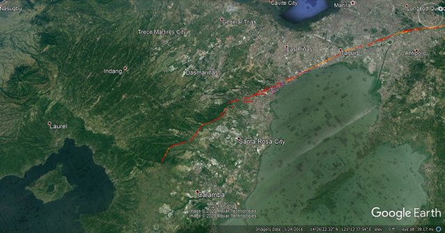
Lastly, it appears Phivolcs has known all along that Taal Volcano lies on the West Valley Fault. Please note carefully the illustration with a logo that mentions DOST and PHIVOLCS. To dispel any more doubts, the caption tells it all, with mention of the former Phivolcs head, the late Dr. Raymudo Punongbayan.
Caption:
Figure III-2. The West Valley Fault extends from Taal Volcano through Laguna, the western edge of Laguna de Bay up to Angat Dam in the north. Modified from Punongbayan (2011).
Source of visual and caption:
https://www.google.com/url?q=http://www.irdrinternational.org/wp-content/uploads/2013/09/FORIN-VFS-Philippines_pt1_web.pdf&sa=U&ved=2ahUKEwjVxqbK5ornAhVaQd4KHTdbAYkQFjAAegQIABAB&usg=AOvVaw3MP9VvKEiusGL7NhQHxfZd
****
POSTSCRIPT: My thoughts on lots of talk about our government to build dedicated evacuation centers nationwide so that when disasters hit, school children will no longer be deprived of their education when schools are used as evacuation centers.
My suggestion is wherever there are vast tracts of idle lands within or in proximity to communities, let the government purchase and develop these lands into NATURE PARKS teeming with carefully planned and planted trees, grass and bushes, with hidden or camouflaged iron poles everywhere with hooks, attachments, or what-have-you for instant installation of giant collapsible tents to temporarily house evacuees. And the park toilets can be constructed to meet the demands of hundreds of evacuees. Maybe we can call these parks BAYANIHAN PARKS in honor of kind hearted people everywhere reaching out to the unfortunate others.
During good times, these are parks; bad times, instant evacuation centers.

salamat sa informtaion na ito, Magiging mabusisi ao pag hanap ng investment.
LikeLike
Good morning, Tulisanes. From your study, do you see Palawan as really protected from earthquake and tsunami? Could you please explain? Thanks for your reply
Sent from Yahoo Mail on Android
LikeLike