Please check for UPDATED maps and NEW maps in the list below…
 To share in Facebook, please look up and add friend Stu V. StuvWx. You can also get notices of new posts in email by clicking the “Follow” button at the lower right–hand corner of this blog. Thank you.
Maps that are already UPDATED are indicated on their links. For maps still awaiting an update, please come back regularly to check on maps you are concerned about. Or click the “Follow” button on the lower right so you will be notified through e-mail when posts are made. NOTE: The updating of earthquake maps proceeds at random….
- Homepage
- Is your house standing on an earthquake faultline? (though this was posted in the early days, it is still a good post. For targeted and updated info, pls. see below the list of newly identified communities that have been sitting along on a fault line.)
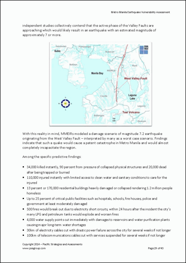
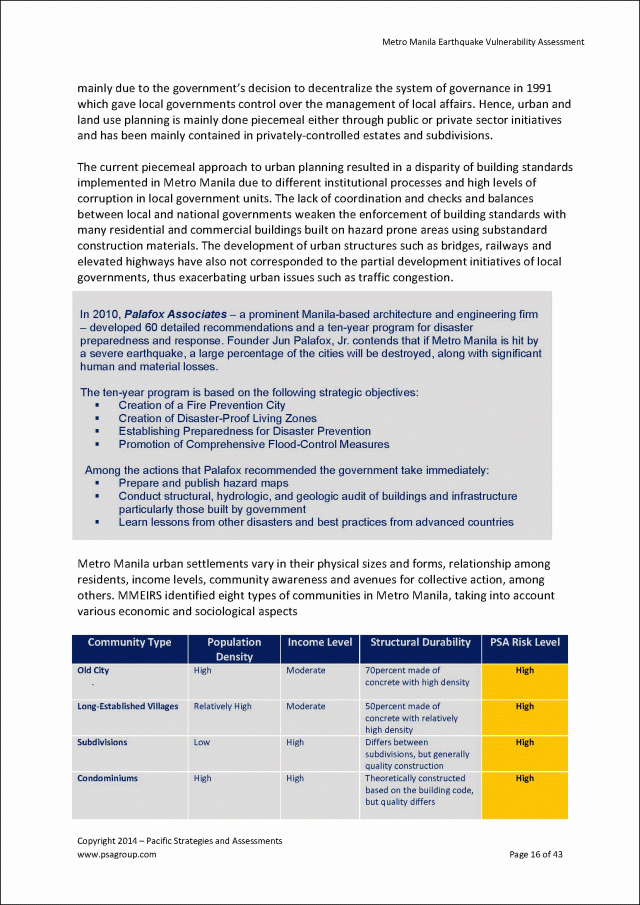
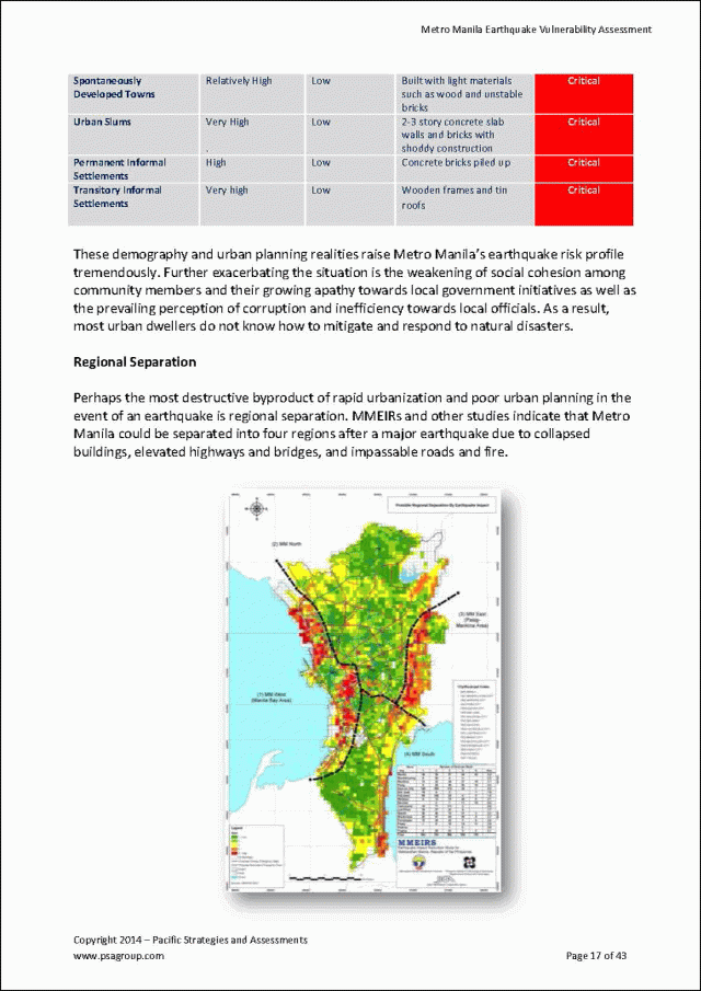
- MMEIRS Scenario 8: Magnitude 7.2 Earthquake along the West Valley Fault System by JANE T. PUNONGBAYAN, Ph.D.
- MMDA Disaster Preparedness Program
- Earthquake Personal Preparedness Plan
- Correct Earthquake Response: DROP, COVER, HOLD ON
- “The Triangle of Life” NOT true …an urban legend?
- Historical Philippine Earthquakes from 1599 to 1909
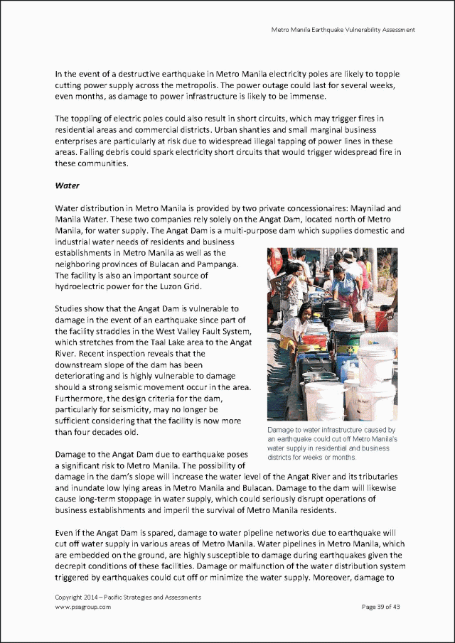
- WHAT IF ANGAT DAM COLLAPSES? In the Line of Fire.
- WHAT IF ANGAT DAM COLLAPSES? …water seeks its own level.
- Q & A (Quakes and Answers)
- “So what about Eastwood Greenview in the shadow of Wawa Dam and La Mesa Dam?”
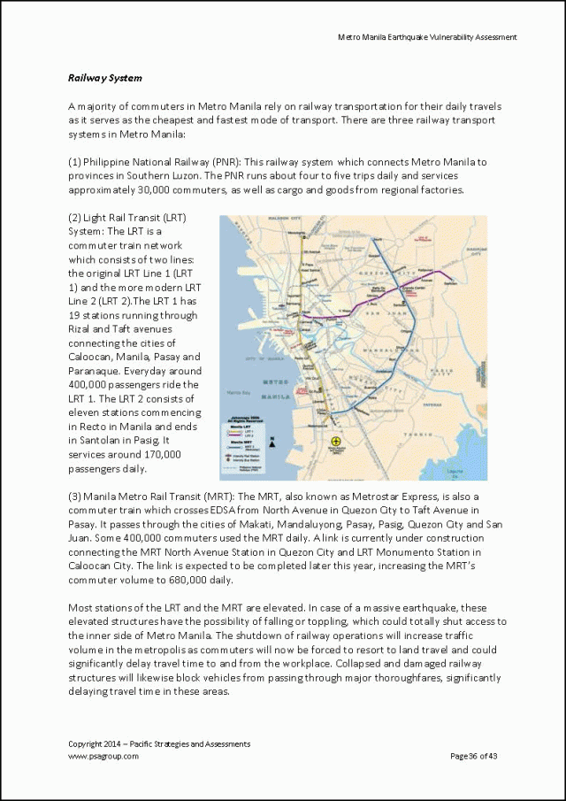
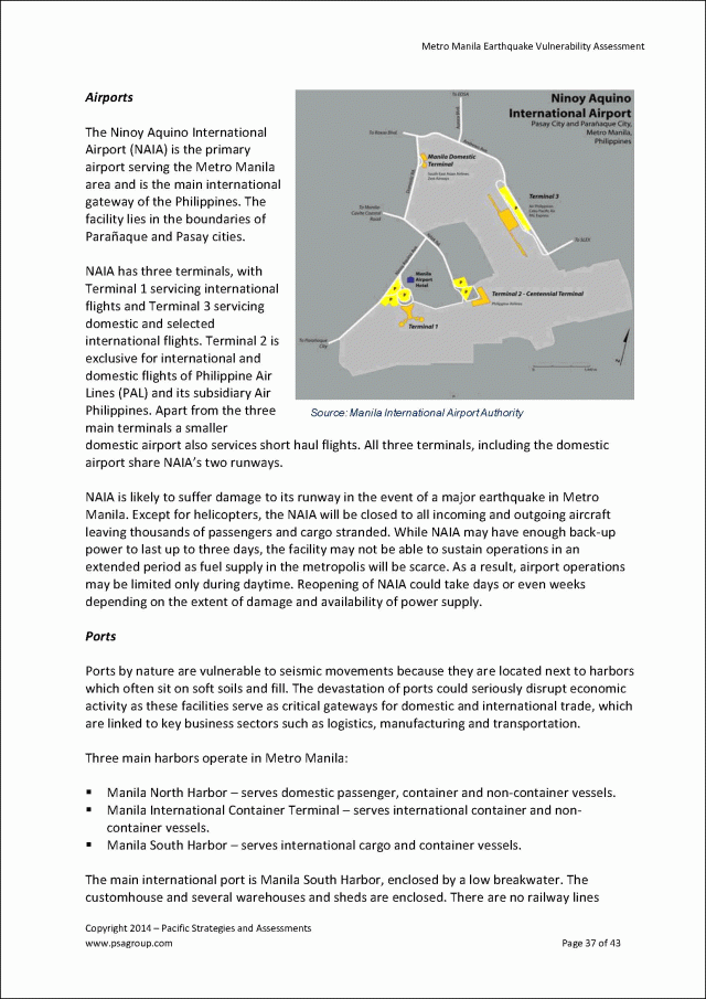
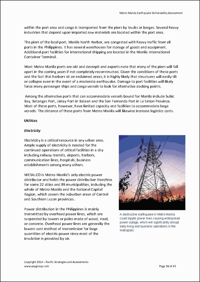
- Metro Manila Earthquake Vulnerability Assessment (November 2014)
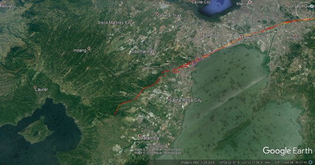
In the order of their location from north-east to south-west, these neighborhoods lie directly on the deadly path of the Marikina Valley Fault Line System:
- Banai Ville and Catalino 1 in Brgy. San Isidro, Montalban
- Jovil 3 in Brgy. San Isidro, Montalban
- Phase 1-A Sub Urban in Brgy. San Jose, Montalban
- Christineville & Pamayanan ng Tagumpay in Brgy. San Jose, Montalban
- Mediterranean Heights Phase 1, Bukluran Hilltop Abatex and Children Mission Foundation in Brgy. San Jose, Montalban
- San Mateo and Montalban (on the lesser known East Valley Fault)
- Bagong Silangan, Filinvest Heights and Sitio Bakal
- Filinvest Homes 2
- Villa Amor Uno and Filinvest Homes 2
- Richville, Garland Woodcrest Forest and North View 1
- Richville and Matandang Balara
- Buenavista Ville and Batasan Hills
- LOYOLA GRAND VILLAS, CAPITOL PARK HOMES, AND BUENAVISTA VILLE (2015) – UPDATED – 05/30/2015
- LOYOLA GRAND VILLAS (2015) – UPDATED – 05/29/2015
- Brgy. Barangka in Marikina
- Ateneo Campus
- Brgy. Barangka, Loyola Subd. and Loyola Grand Villas
- BLUE RIDGE B, CINCO HERMANOS, INDUSTRIAL VALLEY, MONTE VISTA, AND URBAN BLISS (2015) – UPDATED – 06/01/2015
- Brgy. Libis in Quezon City
- Valle Verde 6, Greenmeadows, and White Plains
- Valle Verde 1 Through 5
- KAWILIHAN VILLAGE AND BAGONG ILOG (2015) – UPDATED – 06/04/2015
- EAST AND WEST REMBO (2015) – UPDATED – 06/05/2015
- Rizal and Pembo
- STO. NINO VILLAGE, WILDCAT VILLAGE AND PALAR VILLAGE (2015) – UPDATED – 06/07/2015
- Central and North Signal Villages
- “The South”
- Overview of Muntinlupa
- Brgys. Sucat, Buli and Cupang in Muntinlupa
- Brgy. Alabang in Muntinlupa
- Brgy. Bayanan in Muntinlupa
- Brgy. Putatan in Muntinlupa
- National Road in Tunasan, Muntinlupa
- Sto. Nino Village (Phase 1) in Muntinlupa
- Tunasan Proper in Muntinlupa
- Tunasan-Cuyab Boundary
- St. Peregrine Laziosi Parish and Warehouses in Muntinlupa
- R.M. Tiosejo Subdivision in Muntinlupa
- Parkhomes in Muntinlupa
- Parkhomes and Sto. Nino Village in Muntinlupa
- Parkhomes and Villa Carolina 1 in Muntinlupa
- Susana Heights in San Pedro, Laguna
- Monark, MMG and Holiday Homes in San Pedro
- La Marea Hills and Brgy. San Antonio in San Pedro
- Calendola, Harmony Homes, Villa Olympia 4, Stonecrest and Brgy. San Jose in G.M.A. Cavite
- Villa Olympia 6 and Juana 3
- Brgy. San Jose, Juana 3 and Southbreeze
- The Manila Southwoods & Manila Southwoods Golf and Country Club in Carmona, Cavite
- San Lazaro Race Track & Casino Filipino in Carmona, Cavite
- The Beacon Academy, Inc. in Biñan, Laguna
Into Unknown Territories
- What about Eastwood City?
- What about Bonifacio Global City?
- What about Ortigas District?
- Where on Earth (for selected requests only)

In Focus:
If you know them, tell them …maybe in the future, that will one day save people.
- SCHOOLS ON THE FAULT LINE…
- CHURCHES: St. Peregrine Laziosi Parish, San Jose Manggagawa Chapel, and Camp Atienza Chapel
- SM Center Muntinlupa
- City Hall of Muntinlupa
- Universal Robina Corp. (2015) – NEW – 06/04/2015
- …
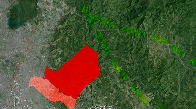
2015 Fault Trace vs. 2010 Fault Trace


 * * *
* * *
 * * *
* * *
 * * *
* * *
 * * *
* * *


 * * *
* * * * * *
* * * <
<